
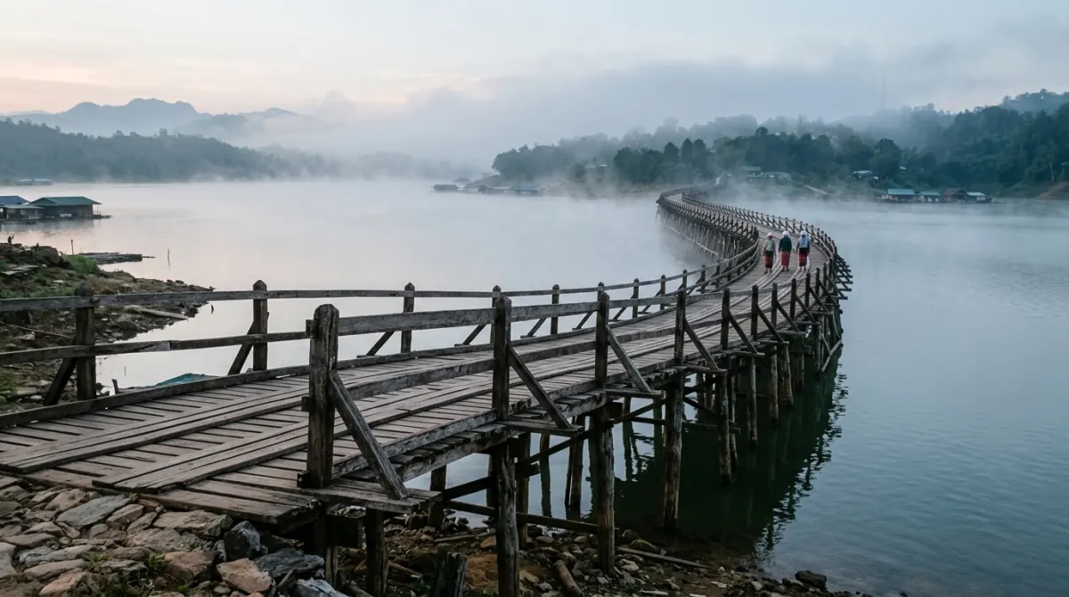
Sangkhlaburi is about 220 km and three and a half to four hours from Kanchanaburi town on a single mountain road. As a day trip that is seven or eight hours in a vehicle for a few hours on the ground. It is not worth it. Stay one night, be on the Mon Bridge at dawn, and it is.
At a glance
| Where it is | Sangkhla Buri district, far northwest Kanchanaburi, on the Myanmar border |
| From Kanchanaburi town | About 220 km, all of it on Highway 323 — there is no alternative route |
| Realistic drive time | 3.5–4 hours each way with no stops; nearer 5 with a meal and a break |
| From Bangkok direct | Roughly 350 km and six hours or more — the Bangkok–Kanchanaburi leg plus this one |
| The bridge | Uttamanusorn Bridge (Saphan Mon), 445 m, wooden, pedestrians only, free, no gate |
| Dawn alms-giving | Daily, around first light — roughly 06:00, but no fixed published time |
| Sunken temple | Wat Saam Prasob. Roughly late March to early June you can walk it; roughly November to January it is a boat trip |
| Boat to the temple | About 250–400 THB (US$7–12) per boat, not per person, for around an hour |
| Three Pagodas Pass | Around 20 km north of town. Crossing into Myanmar is not reliably open to foreign passport holders |
| Minimum sensible trip | One night. Two if you want an unhurried morning |
220 km on one road
Sangkhlaburi sits at the top end of the Vajiralongkorn reservoir — Khao Laem on older maps and signage, the same body of water — in the corner of Kanchanaburi province that touches Myanmar. From Kanchanaburi town it is about 220 km, and every one of those kilometres is on Highway 323. There is no faster road, no bypass and no shortcut.
The first 150 km or so, up through Sai Yok and on to Thong Pha Phum, moves reasonably well. After Thong Pha Phum the road climbs into the hills around the reservoir and stops being a highway in any useful sense: roughly 70 km of near-continuous bends, climbs and descents, with slow trucks and no overtaking room. That final stretch alone eats well over an hour. Anyone in your group who gets carsick will get carsick here, and there is nowhere sensible to stop while it happens.
Three and a half hours is a good run. Four is normal. Five is what it takes once you have stopped to eat and stand up. Doubling that for a return trip in one day leaves you three or four hours in Sangkhlaburi, which is not enough for the one thing worth coming for.
By public transport, buses and minivans run up the same road from Kanchanaburi bus station. Budget roughly 110 to 220 THB and 3.5 to 5 hours: published fares and journey times conflict across sources by more than any single service can explain, so plan on the slow end and confirm the fare at the terminal counter on the day. Air-conditioned minivans are faster than the government bus and considerably less comfortable on the bends. Getting to Kanchanaburi from Bangkok and the Airports covers terminals and fares in detail.
The Mon Bridge and the dawn alms round
The Uttamanusorn Bridge — everyone calls it Saphan Mon, the Mon Bridge — is the longest wooden bridge in Thailand and is usually called the second longest in the world after U Bein in Myanmar, a ranking no official source confirms. It crosses the Songkalia river to connect the Thai side of Sangkhlaburi with the Mon village of Wang Kha, which the reservoir cut off when it filled in 1984.
Its length is given as 445 m by the most careful source available, and as 800 or 850 m by a great many travel sites and signboards. The larger figure appears to be wrong and repeated. Either way it is long enough that you cannot see one end clearly from the other, and it takes several minutes to walk.
It was built between 1986 and 1987, largely by hand and largely by Mon villagers, at the instigation of Luang Pho Uttama, the Mon monk who led the community here and whom the bridge is named for. It replaced a bamboo crossing that charged a baht to use. On 28 July 2013 a 30 m section collapsed under floodwater; flash floods took the gap out to 70 m, and the bridge did not fully reopen until 18 October 2014 — dates that come from secondary accounts rather than a municipal record. It is a footbridge — no cars — it is free, and there is no gate or opening time.
Which brings us to the reason to sleep here. Every morning at first light, monks from Wat Wang Wiwekaram walk across the bridge to collect alms, and Mon residents kneel along the planks to offer rice. It is a working daily observance, not a performance, and it happens whether or not anyone is watching. It is also over well before a car that left Kanchanaburi at 07:00 could possibly arrive. This is the single fact that decides the chapter: the bridge is a pleasant twenty minutes at midday and something quite different at 06:00, and only one of those is available to a day-tripper.
No temple or municipal body publishes a start time. Visitor accounts consistently put it around 06:00, earlier in the hot months, and it is short. Ask your guesthouse the night before rather than trusting a figure from the internet, and if you intend to join in rather than watch, buy the alms set locally and follow what the people around you are doing.
The sunken temple is a reservoir level, not a fixed sight
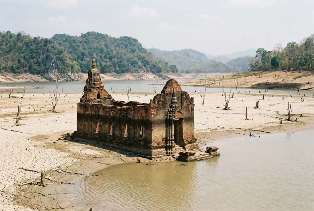
Wat Saam Prasob is the old Wat Wang Wiwekaram, abandoned and drowned when the Vajiralongkorn dam closed and the reservoir began filling in June 1984, taking the original town with it. What remains is a roofless hall, a line of columns and a Buddha image standing in open water where three rivers meet.
This is the most-searched question about Sangkhlaburi and the one most often fudged. The reservoir is not a lake that rises and falls with the rain; it is a working hydro reservoir that the electricity authority fills through the southwest monsoon and draws down through the dry season. The water level follows a dam schedule, and the temple appears and disappears with it.
The pattern in a normal year:
| Roughly | Reservoir | What you get |
|---|---|---|
| Late March to early June | Lowest | The temple stands clear on dry ground. You can walk in, around and through it, and in the driest years reach it on foot from the shore |
| February to March | Falling | Increasing amounts of structure exposed; you can usually land and walk on part of it |
| July to October | Refilling | Going back under. By September typically only a metre or two shows above the surface |
| November to January | Highest | A boat trip. You circle the tops of the walls and the Buddha and look at them |
Treat those as tendencies rather than a calendar. A heavy monsoon or a change in release schedule shifts the whole thing by weeks, and one published account from late December found the temple still well out in deep water. The reliable move is to check the current level: the Thai national water portal at thaiwater.net publishes the Vajiralongkorn reservoir level daily, and a Sangkhlaburi guesthouse will tell you plainly what is showing this week. As of late August 2026 the reservoir stood at roughly 149 m above sea level and about three-quarters full — mid-refill, as the season would suggest.
Boats leave from near the Mon Bridge. Expect to pay somewhere around 250–400 THB (US$7–12) for the boat rather than per head, for about an hour, and expect to negotiate. No operator publishes a rate, so the figure moves with the season and with how many other people are waiting.
Wang Kha and the morning market
Across the bridge is Wang Kha, where a large part of the population is Mon rather than Thai — a people from what is now Mon State in Myanmar, many of whose families arrived here across several decades of conflict on the other side of the border. Mon is the first language for a good number of residents, and it is normal for a household to speak Mon at home, Thai in the shops and some Burmese in the market. Legal status is uneven, which is a live local issue rather than a cultural detail, and it is why the checkpoints on Highway 323 exist.
On the high ground above the village stands the new Wat Wang Wiwekaram, built after the old one went under, with Luang Pho Uttama's chedi nearby — a gilded stupa modelled on the Mahabodhi temple at Bodh Gaya. Beneath it is a small market of Myanmar goods: longyis and cotton, thanaka bark and the paste made from it, jade of wildly varying honesty, lacquerware and cheroots. Prices are set for visitors and the quality is mixed, but it is cross-border trade rather than a souvenir arcade.
The better market is the town one on the Thai side, early. This is where the Burmese and Mon influence on the food shows: fish-broth noodle soups eaten standing up, fermented tea-leaf salad, fried snacks and curries that lean sour and pungent in a way central Thai cooking does not. It runs at dawn and is largely finished by mid-morning, which is another argument for the overnight. Nobody publishes hours for it; go when you get off the bridge.
Karen villages sit in the hills around the town and are reached on foot with a local guide. Karen and Mon are separate peoples with separate languages, and conflating them is the standard visitor error.
Three Pagodas Pass is a border you probably cannot cross
Three Pagodas Pass is around 20 km north of Sangkhlaburi at Ban Phra Chedi Sam Ong. The pagodas themselves are three small whitewashed stupas by the roadside, in the form usually dated to 1929, marking a pass that armies and traders have used for centuries. They take five minutes to look at. Nobody has ever driven four hours for the pagodas.
The draw was always the possibility of stepping across into Payathonzu on the Myanmar side. That is where the situation needs care. This has never been a full international crossing — it has operated as a temporary checkpoint under local arrangement, and English Wikipedia records that as of 2011 Thai nationals were admitted and other nationalities were not. Since the 2021 coup, southeastern Myanmar has been contested ground. In June 2024 Burma News International reported that both Thai authorities and armed groups on the Myanmar side had blocked cargo traffic through the trading post from 17 June, with individuals still crossing on foot carrying small quantities of goods.
What that adds up to for a visitor in 2026: assume you are not crossing. Some travel pages still describe a day pass for around 500 THB or US$10 with your passport held at the checkpoint, and that arrangement may or may not be operating on the day you arrive. The current status for foreign passport holders could not be confirmed from any government or official source, and a border in this condition can change between one week and the next.
Worth it overnight, not worth it as a day trip
Go if you have three days or more in Kanchanaburi, you are willing to sleep in Sangkhlaburi, and what you want from the province is people and water rather than another waterfall. Go if you want the bridge at dawn, which is the strongest single hour anywhere in Kanchanaburi outside the war sites. Go if you are travelling between late March and early June and want to walk inside a drowned temple, which is an unusual thing to be able to do and is possible for only part of the year.
Do not go if you have two days or fewer — spend them on the Death Railway sites and Erawan, both of which reward the time far better per hour. Do not go as a day trip: eight hours of driving buys you the midday version of everything above, which is the weak version. Do not go with small children or with anyone who suffers on winding roads. Do not go in November, December or January expecting to walk around the sunken temple, because you will be looking at wall tops from a boat. And do not go for Three Pagodas Pass.
If you do go, a private car makes the overnight version easier to build: leave Kanchanaburi in the afternoon, break the drive at Hellfire Pass or the hot springs, and come back the next day at your own hour rather than around a bus timetable.